
Farm, Pond and Woodland
Maps
The earliest record of the pond is recorded on the Tithe map of 1860 (see origins). It showed an area up to where the bridge stands now on Church Road, that leads to Lower Bodham then West Beckham. By the first edition of the Ordnance survey maps, twenty years later the pond had already silted up to a similar shape that it remained in for the next 75 years.
It would seem likely that the pond was dug on where the streams from Baconsthorpe and Bodham meet, hence the parish boundary running through the pond, and the Tithe map may have reflected the boggy nature of the land rather than the exact extent of the pond.
An attempt to dredge the pond in the 1950’s made some improvement but by 1980 this effort had been largely reversed (see previous preservation), so the 1988 aerial photo and the Ordnance survey map one hundred years prior are remarkably similar.
Since 1990 owing to the lowering of the water level overall the reeds have invaded dramatically, (see Wall Restoration and Dredging pages for action planned for restoration).
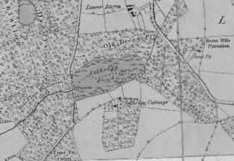
1st edition of the ordnance survey map of the pond.
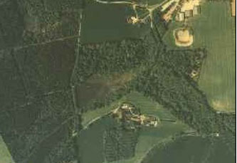
Aerial photo of the pond in 1988.